CNN —
Several days of heavy rain are forecast across portions of the southern US this week, which could improve persisting drought conditions but also lead to significant flooding.
“A prolonged rainfall event is expected across the Mississippi/Tennessee Valleys beginning Monday and extending into the weekend, as multiple waves of rainfall sweep eastward along a stalled frontal boundary,” the Weather Predictions Center tweeted.
This stalled front, combined with a plume of very moist air surging north from the Gulf of Mexico, will set the stage for a heavy rain event across the Tennessee and Mississippi River Valleys Monday into Tuesday.
Both regions are still dealing with moderate to severe drought conditions (Level 1 and Level 2 out of 4), which have expanded across much of Tennessee and northern Alabama over the last week, according to the US Drought Monitor.
“The threat for flooding will start late Monday into early Tuesday for areas south of I-40, especially near the Alabama border,” the National Weather Service office in Nashville, Tennessee said. “The flood threat will then expand northward across (middle Tennessee) Tuesday and Wednesday.”
It is important to note while the “exact rainfall forecasts will change, and the main axis of heavy rain may shift north or south, several inches of rainfall will be likely,” the weather service in Nashville pointed out.
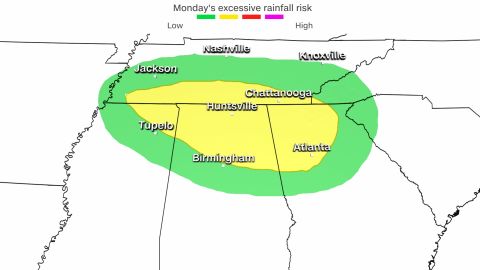
The threat for heavy rain has prompted the prediction center to issue a Level 2 out of 4 slight risk for excessive rainfall on Monday for nearly 10 million people across portions of Mississippi, Tennessee, Alabama, and Georgia, including Atlanta in Georgia, Huntsville in Alabama, and Chattanooga in Tennessee.
“There should still be a sizable swath of more than 2 inches of rain for far southern Tennessee and northern Alabama primarily,” the prediction center said. “There certainly is potential for isolated to widely scattered amounts over 3 inches, which certainly could pose a flooding threat, especially should that occur over downtown Huntsville or Chattanooga.”
The local weather service offices in Huntsville, Alabama, and in Nashville, Tennessee, may issue flood watches later this week.
“If rainfall becomes especially heavy or pockets of heavy rain move across the same areas repeatedly, more significant flash flooding will occur,” the weather service in Nashville warned.
Many locations across the southern US could see rain every day this week, including Memphis, according to the weather service.
Another system is forecast to bring even more rain to the southern and eastern US later in the week as well. Widespread rainfall totals of 3 to 5 inches are forecast through Friday, but isolated locations could see higher totals before the week’s end.
Persistent rains this week could improve drought across the region this week, and may also aid in elevating record-low water levels across the Mississippi River, at least temporarily.
“Flooding may develop, starting early in the week for low lying and flood prone areas, and along small streams,” the weather service in Nashville said. “Rises on larger rivers will occur mid to late week.”
The Mississippi River at Memphis is about 8.5 feet below the low water stage. By Thursday of this week, the number is expected to improve slightly to 5.5 feet below low water stage.
So, while the rain will help, it won’t be enough to completely pull them out of the low water stage.